The U.S. is staring down a warmer-than-usual fall as the latest Climate Prediction Center (CPC) forecast paints a familiar picture: widespread warmth, patchy drought, and the growing influence of a likely La Niña by the end of 2025.
While much of the country basks in mild autumn conditions, experts are watching the Pacific with concern—and curiosity—as sea-surface temperatures cool, setting the stage for what could be another winter steered by La Niña’s hand.
Table of Contents
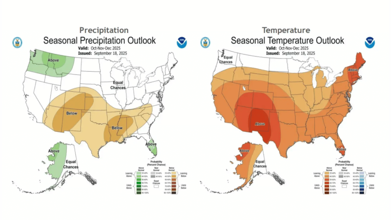
What the Forecast Maps Reveal

According to the CPC’s official outlook for October–December 2025, nearly the entire continental U.S. leans warmer than normal. The Northeast, especially New England states like Vermont, New Hampshire, and Maine, is pegged for the highest likelihood of above-average temperatures. The **Southwest—stretching through Arizona, New Mexico, and Texas—**is also expected to stay toasty well into winter.
Here’s a quick glance at the temperature and precipitation expectations:
| Region | Temperature Outlook | Precipitation Outlook |
|---|---|---|
| Northeast (NY to ME) | Above average | Near normal |
| Southwest (TX, NM, AZ) | Above average | Below average |
| Northwest (WA, OR, ID) | Near normal | Above average |
| Midwest & Plains | Variable, cooler mid-season | Near/below average |
| Southeast (FL, GA, AL) | Warm | Florida: Above average rain |
The full map, available via the NOAA Climate Prediction Center, combines long-term climate trends, soil moisture data, and ENSO (El Niño–Southern Oscillation) projections to produce these forecasts.
The La Niña Factor: Cooling Pacific, Changing Patterns

La Niña, for the uninitiated, is the cool phase of the El Niño–Southern Oscillation (ENSO) cycle—a seesaw of ocean temperatures that swings global weather patterns. It cools the central and eastern Pacific Ocean, typically steering the jet stream north and drying out the southern U.S.
The CPC currently pegs the probability of La Niña developing between October and December at 71 percent, according to its ENSO Diagnostic Discussion.
“Even if La Niña doesn’t officially form, we can still get La Niña-like effects,” explained Michelle L’Heureux, a leading CPC climatologist. That means warmer conditions across the southern states and fewer soaking storms across the central belt—a pattern that could exacerbate drought in regions already short on rainfall.
How a Weak La Niña Could Complicate the Season

Interestingly, both NOAA and AccuWeather note that if La Niña turns out to be weak, other systems could tug the weather in unpredictable directions. In an advisory shared with Newsweek, AccuWeather warned that a “weak La Niña would open the door for other factors”—such as Arctic intrusions or shifting jet streams—to interrupt otherwise mild patterns.
AccuWeather’s Paul Pastelok, one of the firm’s veteran long-range forecasters, added a few more details to that picture. “October looks warmer from the Plains to the East,” he said, “but mid-month, cooling could kick in across the northern Rockies and northern Plains.”
By November, he expects more cold fronts cutting through the Midwest, while December may finally see a stronger pattern emerge—with cooler air more likely to settle across the northern tier.
In short? A warm start, a bumpy middle, and an uncertain winter finish.
What It Means for the Average American
For most of the U.S., a mild autumn might sound pleasant—but it comes with trade-offs. Energy bills could see temporary relief thanks to reduced heating demand, but dryness in the Southwest and central states could intensify water shortages and wildfire risks.
Farmers in Texas and Oklahoma may struggle with limited soil moisture heading into winter planting, while northern growers could see better moisture retention, at least early in the season.
Meanwhile, regions like Florida and the Pacific Northwest, both projected to get above-normal precipitation, might face flooding risks if tropical remnants or atmospheric rivers line up just right.
The National Weather Service (NWS) continues to monitor these regional contrasts closely, noting that “outlooks such as these do not just incorporate La Niña information; they also include longer-term climate trends,” according to CPC guidance.
What’s Next: Watching the Pacific Closely
All eyes now turn to the equatorial Pacific, where satellite readings from NOAA’s Oceanic Niño Index will confirm whether ocean temperatures cross the threshold for a true La Niña.
If they do, expect the winter of 2025–26 to feature the classic La Niña pattern: wet in the Northwest, dry in the South, and cold snaps sneaking into the Midwest.
But if the cooling falters, we may get something murkier—a hybrid winter that defies neat categorization, driven by a tug-of-war between Pacific patterns and atmospheric chaos.
As Pastelok put it, “Confidence is a bit lower in November, but higher in December.” Translation: enjoy the warmth while it lasts, because the jet stream may have a few surprises left.
FAQs
What is La Niña, and how often does it occur?
La Niña is the cool phase of the ENSO cycle, typically recurring every 2–7 years. It can last 9–12 months, sometimes longer.
How does La Niña affect U.S. weather?
It usually brings cooler, wetter conditions to the northern states and drier, warmer weather across the South.
When will we know for sure if La Niña has formed?
NOAA’s Climate Prediction Center updates its ENSO outlook monthly. Confirmation usually comes when the Oceanic Niño Index (ONI) remains below -0.5°C for several consecutive months.
Does La Niña impact hurricane activity?
Yes. It can enhance Atlantic hurricane activity by reducing wind shear, allowing storms to strengthen more easily.